We were late leaving Dawson City on Friday 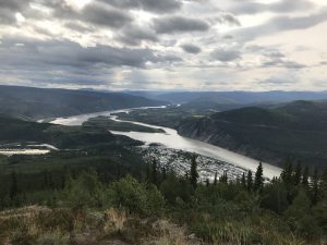 August 17th, stopping to grab much needed showers and a few supplies before hitting the Dempster Highway. Before leaving town we wandered up to an area known as the Midnight Dome. At an elevation of 2911 ft, this lookout offers a panoramic view of the Klondike and Yukon Rivers. This would have been the perfect spot to catch the Northern Lights which had lit our way home the previous night.
August 17th, stopping to grab much needed showers and a few supplies before hitting the Dempster Highway. Before leaving town we wandered up to an area known as the Midnight Dome. At an elevation of 2911 ft, this lookout offers a panoramic view of the Klondike and Yukon Rivers. This would have been the perfect spot to catch the Northern Lights which had lit our way home the previous night.
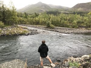 After this quick stop it was time to continue on our journey northward. We spent our first evening in Tombstone Territorial Park camped in a gravel pit alongside the North Klondike River at approximately km 60. Paul was lucky enough to catch a few arctic grayling that night before calling it quits for the night.
The next day we woke early to head to the Visitor’s Intepretive Centre in Tombstone Territorial Park. We had hoped to do some backcountry camping along the well known Grizzly Lake hiking trail, but were informed that this route had been hit with extremely inclement winter-like weather so hiking was not recommended. A number of hikers had been trapped for a few days awaiting a good weather window to make the hike out. We hunkered by a fire in the Intepretive Centre, enjoyed freshly brewed Labrador tea and contemplated our next move.
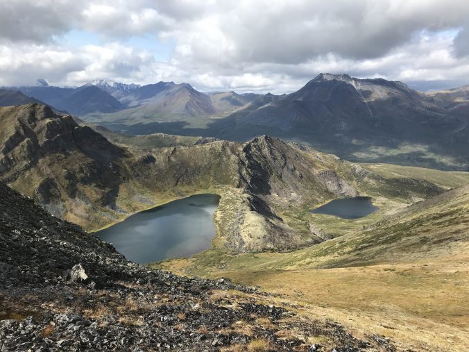
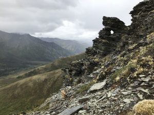
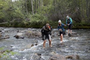 Based on recommendations from the staff, we decided to hike Fold Mountain, which is visible from the Interpretive Centre. This was not an established trail, but it promised amazing views of the valley and two lakes hidden behind the mountain. The skies looked a little threatening, so we packed our rain gear in anticipation of a wet hike. The hike necessitated a river crossing of the chilly Klondike River. I watched the first 3 in our group roll their pants to their knees and made it across. Unfortunately for me, everyone else was 5’10 and up! The river hit me mid-thigh, but luckily my pants were quick dry. Oh the joys of being vertically challenged!
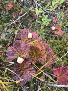
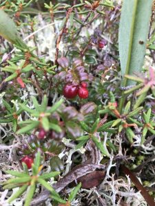
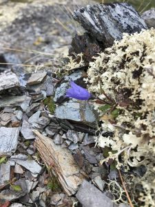 The arctic flora and fauna on Fold Mountain were incredibly memorable – like nothing I’ve come across hiking before. The lichen and spongy ground was beautiful and forgiving to walk on and the arctic plants smelled intoxicating, particularly the Labrador! We stopped repeatedly to gorge ourselves on mountain berries including cloud berries, blueberries, cranberries and crow berries. the cloud berries were a group favourite – they look similar to a light coloured blackberry, with burgundy leaves similar in shape to a strawberry plant. The berries range in colour from white to peach to salmon in colour and the taste is amazing but difficult to describe…like a juicy buttery flavoured delight! I’ve never snacked so much on a hike 🙂
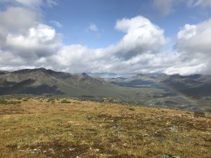
It began to rain when we stopped for lunch at a nice lookout spot over the valley. We could see spots of bluebird sky poking through the clouds and made the decision to continue on just as a rainbow greeted us over the valley.
As we hiked along, Antoine spotted two caribou high above us on the ridges where we were 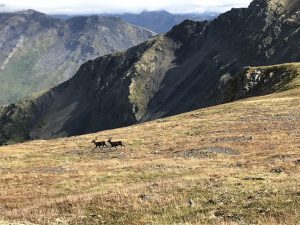 headed. We were also consistently greeted by the squeaks of arctic ground squirrels who made the mountainside their home. We eventually crossed the ridge where we’d first viewed the caribou and realized it was a false summit, with a higher peak above us. We continued along as the weather grew increasingly nice in hopes of reaching two mountain lakes. As we plodded along upwards, my cousin Paul shouted at us to get down! My first thought was bear, but as we peeled upwards we saw the two caribou descending towards us. We stayed down and quiet and experienced a close up encounter with these gorgeous animals. They were far bigger and darker than expected – photos from my phone camera cannot do them justice, nor do they show how close we were to them. It was better to put the phone away and just take in the viewing!
headed. We were also consistently greeted by the squeaks of arctic ground squirrels who made the mountainside their home. We eventually crossed the ridge where we’d first viewed the caribou and realized it was a false summit, with a higher peak above us. We continued along as the weather grew increasingly nice in hopes of reaching two mountain lakes. As we plodded along upwards, my cousin Paul shouted at us to get down! My first thought was bear, but as we peeled upwards we saw the two caribou descending towards us. We stayed down and quiet and experienced a close up encounter with these gorgeous animals. They were far bigger and darker than expected – photos from my phone camera cannot do them justice, nor do they show how close we were to them. It was better to put the phone away and just take in the viewing!
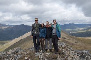
We continued along for awhile longer, ending with gorgeous views of both lakes below. We’d met a journalist and photographer at the Interpretive Centre who joined us on the hike, and so we managed to get some epic non-selfie group photos at the top. Thanks Jimmy for your awesome photography skills!! We will have to share these photos later on – I thought that we transferred them onto my laptop but it seems they did not save. Bummer! I stole a photo from Nat instead, which includes Jimmy 🙂
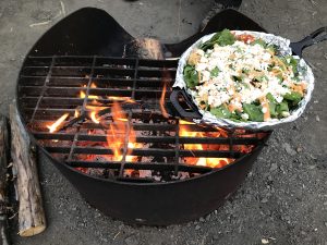
We chose an easier route to descend in order to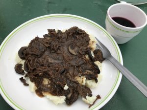 bypass the bog and deeper river crossing we’d originally tried. From up high we could see the river braided further down, and we crossed back over more easily this time. We met up with Derek and Jeni on the trail back, and joined them at their campsite in the Tombstone Territorial campground. That night we enjoyed great company and food including moose meat, mushroom gravy stop potatoes, maple syrup by the spoonful and nachos baked over the fire. This was a day to remember!
bypass the bog and deeper river crossing we’d originally tried. From up high we could see the river braided further down, and we crossed back over more easily this time. We met up with Derek and Jeni on the trail back, and joined them at their campsite in the Tombstone Territorial campground. That night we enjoyed great company and food including moose meat, mushroom gravy stop potatoes, maple syrup by the spoonful and nachos baked over the fire. This was a day to remember!
The next day we decided to do a day hike to lookout along the Grizzly Lake trail. This was a 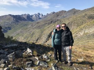 much busier route in contrast to a Fold Mountain, where we never crossed another hiker. This meant no wildlife viewing besides a far friendly arctic ground squirrel who seemed to be used to frequent visitors. The hike to the viewpoint was 3km, but we extended our trip along the ridge line to approximately the 6km point. The sun was shining but the wind was howling. Visibility was perfect to see the snow covered Monolith Mountain and Grizzly Lake below it in the valley. These are vistas that Tombstone had become known for.
much busier route in contrast to a Fold Mountain, where we never crossed another hiker. This meant no wildlife viewing besides a far friendly arctic ground squirrel who seemed to be used to frequent visitors. The hike to the viewpoint was 3km, but we extended our trip along the ridge line to approximately the 6km point. The sun was shining but the wind was howling. Visibility was perfect to see the snow covered Monolith Mountain and Grizzly Lake below it in the valley. These are vistas that Tombstone had become known for.
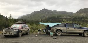
That night we camped at a pullout along the 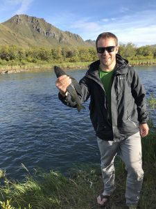 Blackstone Creek at approximately km 98. Antoine caught his first two arctic grayling here, but we threw them back as pasta and dehydrated meat sauce was on the menu. My cousins had spotted large grizzly bear and wolf tracks along the river bed, so we were extremely cautious with our food and grey water that night. We slept the night with no encounters – phew!
Blackstone Creek at approximately km 98. Antoine caught his first two arctic grayling here, but we threw them back as pasta and dehydrated meat sauce was on the menu. My cousins had spotted large grizzly bear and wolf tracks along the river bed, so we were extremely cautious with our food and grey water that night. We slept the night with no encounters – phew!
On Monday August 20th we hit the road again, leaving the boundaries of Tombstone Territorial Park. Next up: the Ogilvie Mountains and Arctic Circle!
Liz & Antoine